Looking at reports from other activators, it appeared that the approaches to the summit of Bald Hill in Marin County were steep, steeper, and steepest. In the hopes of starting the hike with as much elevation gain as possible already behind us, I chose the route that starts at Crest Road in Fairfax.

The information sign for Bald Hill Open Space Preserve stands just past the locked gate where Crest Road becomes Crest Fire Road. There is enough space for two cars to park at the turnaround before the gate.

About a half mile from the gate you come to the spot where the Google Maps pin for is dropped for Sky Ranch Open Space Preserve. The trail system intertwines through both Sky Ranch OSP and Bald Hill OSP, and with the names of both locations sprinkled around on different bits of signage it can get a little confusing as to which preserve you are in. But it doesn’t matter much, just go “up” and you’ll find the summit.

My hiking buddy used an app on her phone to collect some stats on our ascent to the summit of Baldy. From the trailhead, where the equestrian area is, the fire road goes steeply up and over a knoll to where it joins the Worn Spring fire road.

I recommend to take the Sky Ranch trail from the trailhead. This skirts around the eastern side of the knoll and avoids the steep elevation gain, much of which you give right back on the other side. We took this trail on the return leg rather than climbing straight over the knoll again.

The fire road to the summit is a steep climb but offers enough level spots where you can take a rest, hydrate, and catch your breath while watching other much more fit people run right past on their way up the hill!

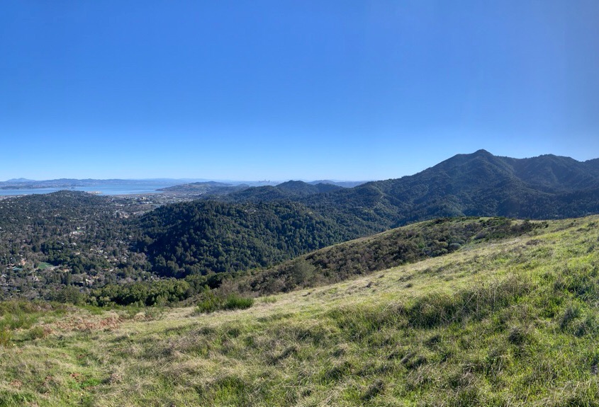
The broad summit and activation zone offers panoramic views of the northern part of the Bay Area, but nothing in the way of antenna supports, so be prepared to supply your own.

With the GRA-3750T vertical antenna and the Mountaintopper MTR-4B on 20 meters I collected 15 QSOs within 20 minutes.

The first call was from K6EL a few miles north on Loma Alta W6/NC-350. The familiar duo of W0MNA and W0ERI checked in from Kansas and WU7H and WW7D were on W7W/CW-068 in Washington state.

After securing the HF operations and a successful activation I gave 2 meters a try. A pair of QSOs on FM was enough before heading back down the hill.

From Bald Hill there are views of Mt. Tam, San Francisco, southern Marin and Bay Area, including Mt. Diablo to the southeast.

73 de W6CSN

Leave a comment